The creation of a cloud-based software program will make all airborne electromagnetic survey data available for the state of Nebraska.
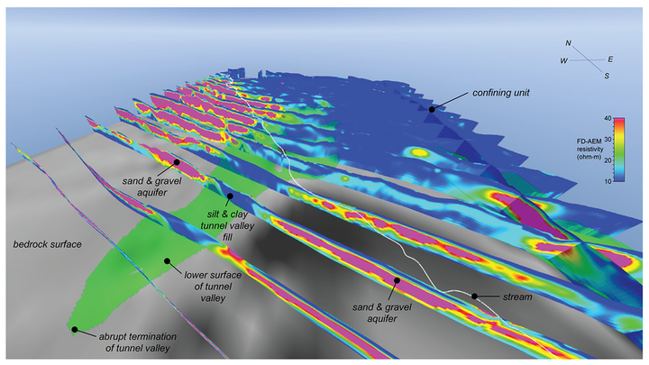
A surge in airborne electromagnetic surveying across the state — a cost-effective method of quickly mapping the Earth’s subsurface over large areas — has created a surge in data. The information, which can inform people’s understanding of how groundwater flows from one area to another, can help the state, counties and natural resource districts make more informed water management decisions.
The program, dubbed the Nebraska GeoCloud, will make this data available, but will also include maps, completed reports, boreholes and model layers. The layers provide information about the depth and thickness of geologic materials, such as aquifers composed of sand or sandstone, and can be used to locate wells, address water quality concerns and refine groundwater management plans. Borehole data is invaluable to the application of airborne electromagnetics.
The project is made possible through a Water Sustainability Grant and matching funds, and is a collaboration among 10 of the state’s natural resource districts, the Conservation and Survey Division at the University of Nebraska-Lincoln's School of Natural Resources, and the U.S. Geological Survey Nebraska Water Science Center.
Nebraska GeoCloud will be developed by I-GIS, a Danish firm that specializes in airborne electromagnetic data management as well as customized 3-D visualization software.
Jesse Korus, a groundwater hydrologist at the School of Natural Resources, is leading the project. Katie Cameron, survey hydrogeologist with the survey division and the Lower Platte South NRD, and Matt Joeckel, state geologist and associate director for the survey division, are assisting.
“The goals of this project fall in line with the mission statements of the Conservation and Survey Division and U.S. Geological Survey, which are tasked with investigating and reporting the geology of Nebraska and the quantity and quality of its water resources,” Korus said.
The Conservation and Survey Division and the U.S. Geological Survey will conduct hydrogeologic studies so they can develop better methods of mapping aquifers and characterizing groundwater resources through the use of airborne electromagnetics, which works by flying a tool over a target area. As it sends an electromagnetic signal toward Earth, the tool records the electrical response of the subsurface.
Clay, for example, is more electrically conductive than sand or gravel and can be easily distinguished from other materials on 2-D and 3-D images created in the software program. This method is able to record extremely detailed information as much as 1,500 feet below the surface.
The project is scheduled for completion in 2020. It will provide natural resource districts, state agencies, consultants and research geologists with access to hydrogeologic data that is necessary for the proper management and protection of Nebraska’s groundwater supplies.
“This is a singular achievement for our survey personnel,” Joeckel said. “It will prove to be an accolade for the University of Nebraska-Lincoln.”


